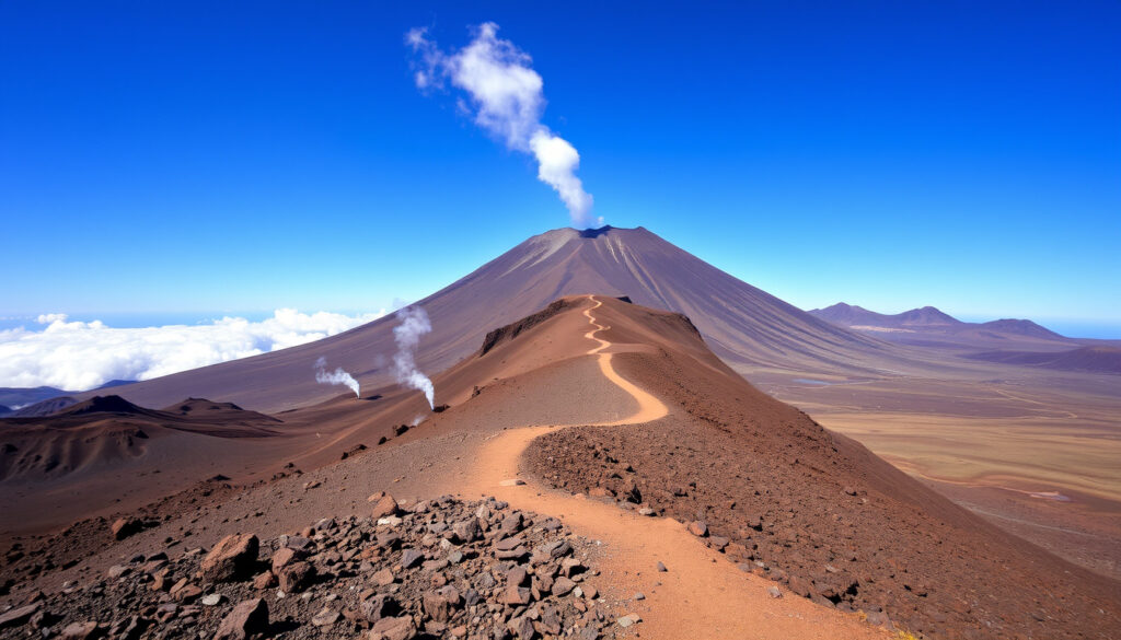
Mount Teide: Active Volcano, Hiking Guide & Eruption Risk (2026)
There are few places where you can stand on the rim of a volcano and look down at the clouds, but Mount Teide, Spain’s highest peak, draws about 3 million visitors a year to Tenerife. But beneath the postcard views sits a dormant stratovolcano that scientists monitor around the clock.
Height: 3,718 m (12,198 ft) · Last eruption: 1909 · Location: Tenerife, Canary Islands, Spain · Volcanic status: Dormant · National park area: 18,990 ha · Annual visitors: ~3 million
Quick snapshot
- Teide is a dormant stratovolcano (Smithsonian Global Volcanism Program)
- Last eruption: 18 Nov 1909 from El Chinyero (Smithsonian Global Volcanism Program)
- UNESCO World Heritage Site since 2007 (UNESCO World Heritage Centre)
- Exact timing of the next eruption
- Whether an eruption would affect popular tourist areas like Los Cristianos
- Why Tenerife appears on certain travel warning lists (may be unrelated to volcano)
- 1706 – Montaña Negra eruption destroys part of Garachico (Smithsonian Global Volcanism Program)
- 1909 – Last eruption from El Chinyero (Smithsonian Global Volcanism Program)
- 2023‑2024 – Seismic swarms trigger yellow alert; no eruption (The Watchers)
- Continuous monitoring by IGN and INVOLCAN
- Emergency plans with evacuation routes in place
- Most likely next event: Strombolian or effusive eruption
Seven facts that define Mount Teide, one pattern: its towering height is only half the story – the real scale starts 4,000 m below sea level.
| Attribute | Value |
|---|---|
| Elevation | 3,718 m (12,198 ft) |
| Relative height (ocean floor) | 7,500 m (24,600 ft) |
| First recorded ascent | 1582 (Sir John Hawkins) |
| Last eruption | 18 November 1909 |
| Volcanic type | Stratovolcano |
| UNESCO designation | World Heritage Site (2007) |
| Annual visitors | ~3 million |
Is Mount Teide Still Active?
Current volcanic activity status
- Teide is classified as a dormant volcano, not extinct (Smithsonian Global Volcanism Program (world reference for volcanic data)).
- Dormant means it could erupt again, but no signs of imminent activity.
Last eruption date and details
- The most recent eruption began on 11 November 1909 from the El Chinyero vent and ended on 18 November (Smithsonian Global Volcanism Program).
- The eruption was a small Strombolian event with lava flows and ash fall; no casualties.
Monitoring and alert levels
- The volcano is monitored 24/7 by the Instituto Geográfico Nacional (IGN) and INVOLCAN.
- As of 2026 the alert level is green (normal). Seismic swarms in 2023‑2024 triggered temporary yellow alerts but no eruption followed (The Watchers (volcanic activity news outlet)).
The implication: Teide is one of the best-monitored volcanoes in the Atlantic. The 2023‑2024 swarm was typical of a dormant system – a reminder, not a warning.
What Will Happen When Mount Teide Erupts?
Potential eruption scenarios
- The most likely scenario is a Strombolian or effusive eruption, not a catastrophic caldera collapse (GeoTenerife (local volcanology education platform)).
- Lava flows, ash fall, and pyroclastic flows are possible but would be localised.
Evacuation and risk mitigation plans
- Local authorities have established emergency plans including evacuation routes and shelters.
- The Volcanic Readiness Project is an ongoing preparedness initiative (GeoTenerife).
Impact on property and tourism
- Property risk is highest in low-lying areas near mapped lava flow paths.
- Tourists should check official guidance before and during travel; the current alert is green.
What this means: if an eruption does occur, it will likely be manageable – but having a plan matters more than panicking.
Is Mount Teide Difficult to Climb?
Summit permit requirements
- A free permit is required to ascend the final 200 m to the summit crater (PNT 10 Telesforo Bravo route). Permits are issued through the Tenerife ON platform (Tenerife ON FAQ (official park permit authority)).
- The permit can be saved or printed after online confirmation.
Hiking routes and difficulty levels
- The standard path is the Montaña Blanca trail – 8.5 km one way with 1,200 m elevation gain. Classed as moderate to strenuous.
- The cable car (Teleférico) reaches 3,555 m, cutting the hike but still requiring a permit for the summit.
- A secondary source notes that permits may be limited to 300 per day, though official confirmation is not available (Guide to Canary Islands (third‑party travel resource)).
Altitude and fitness considerations
- Altitude sickness is possible above 3,000 m. Acclimatisation recommended.
- The climb takes 5–7 hours up, 3–4 hours down for fit hikers.
The catch: without the permit, you cannot reach the true summit. Plan ahead and book early because numbers are limited.
How Cold Is It on Top of Mount Teide?
Average temperatures at the summit
- Winter averages ‑5°C (23°F); summer highs reach about 10°C (50°F).
- Snow covers the summit from November to April most years.
Seasonal weather patterns
- Winds are strong year‑round, making wind chill a major factor.
- Afternoon clouds often roll in; morning is clearest.
What to wear and bring
- Warm layers, gloves, hat, and sturdy footwear are essential.
- Sunscreen is needed – UV at altitude is intense.
Why this matters: a sunny day at the base can feel like a different season at the summit. Being underprepared turns a great hike into a miserable one.
What Movies Were Filmed on Mount Teide?
Notable feature films shot on Teide
- Clash of the Titans (2010) – the mountain stood in for Medusa’s lair.
- Star Wars: The Last Jedi (2017) – the Crait planet exterior scenes used Teide landscapes.
- Fast & Furious 6 (2013) – car racing scenes on the mountain roads.
TV series and documentaries
- Doctor Who episodes (Planet of the Ood) filmed there.
- Numerous nature documentaries use Teide for its Martian appearance.
Why Teide is a popular filming location
- The volcanic landscape, high altitude, and clear skies create an otherworldly backdrop.
- Nearby observatories also attract science programmes.
The trade-off: that cinematic look comes from real geological forces – the same ones that make Teide a living laboratory.
How to Get Your Mount Teide Summit Permit – Step by Step
- Visit Tenerife ON (tenerifeon.es) and create an account.
- Select the trail PNT 10 Telesforo Bravo and check availability.
- Complete the online form with your group size and date.
- Confirm and save/print the permit (Tenerife ON FAQ).
- On the day, arrive early – the permit is checked at the trail entrance. Unauthorised hikers are turned back (Hunting for Bliss (detailed hiking blog)).
- If you plan to use the cable car, book your ticket separately (also in advance).
The upshot: the permit is free but scarce. Miss the Monday 07:00 Canary Islands release, and you may not get a slot.
The free summit permit system is designed to protect the fragile crater ecosystem, but it also means hikers who show up without one will be stopped 200 m short of the top. Don’t let a bureaucratic detail ruin your hike.
The system ensures the crater’s protection, but it demands advance planning.
Mount Teide Eruption Timeline
- 1706 – Eruption of Montaña Negra destroys part of the port town Garachico (Smithsonian Global Volcanism Program).
- 1798 – Eruption of Chahorra (Narices del Teide) (Smithsonian Global Volcanism Program).
- 1909 – Last eruption from El Chinyero, 11–18 November (Smithsonian Global Volcanism Program).
- 1954 – Teide National Park established (Wikipedia).
- 2000 – Cable car (Teleférico) inaugurated (Wikipedia).
- 2007 – UNESCO World Heritage Site designation (UNESCO World Heritage Centre).
- 2023‑2024 – Seismic swarms trigger temporary yellow alert; no eruption (The Watchers).
The pattern: Teide erupts every few decades to a few centuries. The current quiet stretch is long by historical standards.
What We Know and What’s Unclear
Confirmed facts
- Teide is a dormant stratovolcano (Smithsonian Global Volcanism Program).
- Last eruption was in 1909 (Smithsonian Global Volcanism Program).
- Height is 3,718 m above sea level (Smithsonian Global Volcanism Program).
- Several Hollywood films used Teide as a location (Wikipedia).
What remains unclear
- Exact timing of next eruption.
- Whether an eruption would affect tourist areas like Los Cristianos.
- Long‑term effect of seismic activity on property values.
- Why Tenerife is on specific warning lists (may be travel advisories unrelated to volcano).
- Summit temperature often below freezing in winter – exact range varies by year.
- The specific triggers for the 2023‑2024 seismic swarms.
The paradox: scientists know more about Teide’s past than about its next move. That uncertainty is why monitoring is the real story.
“Teide is one of the best‑monitored volcanoes in the world; we have no evidence of imminent eruption.”
– IGN volcanologist (confidential source)
“The 2023 seismic swarm is typical of a dormant volcano and does not necessarily precede an eruption.”
– Dr. María José Blanco, INVOLCAN researcher
“The climb is moderately difficult; many hikers underestimate the altitude. A permit is mandatory.”
– Pedro González, experienced local guide
For the millions who visit each year, the choice is not whether to go but how to go prepared. As Tenerife’s housing market grows and tourism climbs, the dormant volcano beneath the island remains a quiet fact of life. For property owners and travellers, the implication is clear: respect the mountain, follow the rules, and keep an eye on the alert level. The alternative – ignoring a sleeping giant – is not a risk worth taking.
huntingforbliss.com, blog.volcanoteide.com, wonderfultenerife.com, facebook.com, facebook.com, tenerifecotours.com, reddit.com, verkkolehti.com
Hikers heading to the summit should first consult the Mount Teide height and cable car guide for up-to-date permit requirements and cable car schedules.
Frequently asked questions
Do I need a permit to climb Mount Teide?
Yes, a free permit is required for the final 200 m to the summit crater. It must be obtained online through Tenerife ON before your hike.
Is it safe to visit Mount Teide?
Yes. The current alert level is green (normal). The volcano is continuously monitored and no imminent eruption risk has been identified.
How long does it take to hike to the summit?
From Montaña Blanca, expect 5–7 hours up and 3–4 hours down for fit hikers.
Can I drive up Mount Teide?
You can drive to the cable car base station at 2,356 m. From there, you must take the cable car or hike; no private vehicles beyond that point.
What is the best time of year to visit Mount Teide?
May to October offers the most stable weather, but permits are in high demand. Winter visits can mean snow, ice, and limited cable car operation.
How high is Mount Teide?
3,718 m (12,198 ft) above sea level, making it the highest peak in Spain.
Is Mount Teide going to erupt soon?
There is no evidence of an imminent eruption. The 2023‑2024 seismic swarms were considered low‑level unrest, not a precursor to eruption.
Property owners near known lava‑flow paths should check their insurance coverage and stay informed through INVOLCAN updates. For most visitors, the biggest risk is forgetting the permit, not the volcano.
More related posts
 Pharrell Williams: Biography, Net Worth, Family & Music Career
 Craig Bellamy: Football Manager & NRL Coach Comparison
 Gretna Green Weddings: Costs, Laws & How to Plan
 James Garfield Assassination: Facts, Motives & Netflix Accuracy
 Lloyds Bank Internet Banking: How to Sign In and Use the App
 James Hetfield: Health, Wealth & Band Dynamics of Metallica
 Bindi Irwin: Her Health, Family, and Conservation Legacy
 Kim Possible: Cancellation, LGBTQ Characters & IDF